LMA

Ermita de las Nieves: the top of the wall (and the island's oldest weather report)

Lanzarote · 3 min read

Ermita de las Nieves: the top of the wall (and the island's oldest weather report)

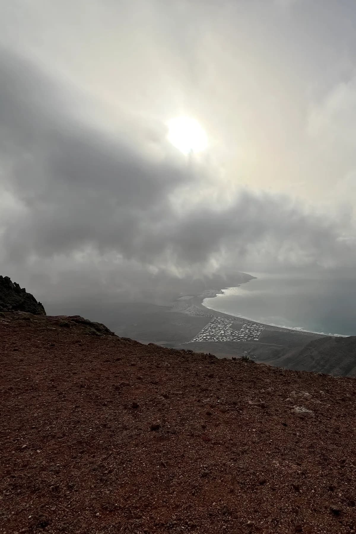
Everyone photographs the Famara cliff from below. Almost nobody stands on its lip. The road up from Teguise's plateau ends near the Ermita de las Nieves, a tiny white chapel at around 600 metres where the island simply stops: beyond the wall, a sheer drop to the Risco coast, with Famara's beach curling gold below, La Graciosa and the Chinijo islands arranged like a fleet, and — on clear days — the whole north of the island at your feet. The chapel of the Virgin of the Snows is the island's oldest high sanctuary, where farmers once climbed to pray for rain from the cloud-catching heights. Paragliders launch nearby; sunset turns the whole rampart pink. Free, unfenced, usually empty. Mind the edge — it's absolutely real.

The Famara massif is the island's weather machine and its oldest bones — the hanging-gardens botany card and the geology cards work its lower floors — but its summit line is an experience of its own: a grassy, windswept upper world that feels borrowed from another latitude, ending in the most dramatic edge in the eastern Canaries.

The Ermita de las Nieves is the human touch that makes it a destination rather than just a drop. A small, whitewashed chapel with a stone cross and a walled forecourt, documented back to the island's early colonial centuries, dedicated to the Virgen de las Nieves — Our Lady of the Snows, a Roman devotion tied to a miraculous August snowfall, transplanted here with gentle irony to the driest island's wettest heights. The logic was practical: these summits catch the trade-wind mists (the alisios card explains the mechanism), and in the hungry centuries, when rain decided everything, islanders processed up here to ask for clouds. The chapel's fiesta each August still brings the faithful, folk groups and picnics; the rest of the year it stands locked and serene, white against enormous sky, one of the island's most photogenic buildings precisely because nobody designed it to be.

The view is the island's best-kept superlative. From the natural balconies near the chapel (and along the summit track towards the Mirador del Bosquecillo picnic area, a fine second stop with its tiny plantation of trees), the cliff drops away in one motion: Famara beach a golden crescent 600 metres below, the surf drawing slow white lines; the Risco coast and Playa del Risco with its salt-pan geometry (card 77); the strait; La Graciosa mapped entire, Montaña Clara and Alegranza queued behind (card 74). Sunset from here — the sun sinking behind the Chinijo islands, the cliff face igniting — is the connoisseur's alternative to the crowded classics. Nearby rises Peñas del Chache, the island's highest point at about 670 metres; its summit wears a military radar and is off-limits, which the chapel's balcony renders irrelevant.

Practicalities, sharpened: come via the LZ-10 from Teguise/Los Valles side (signed Ermita de las Nieves); the top is reliably 5-8 degrees cooler than the coast and the wind is a permanent resident — bring the layer you laughed at in Arrecife. The edge is unfenced along most of the rim: vertigo is data here, children and drone pilots need active supervision, and gusts near the lip are no joke. Paragliders use launch zones along the crest when conditions allow — watching them step into 600 metres of air is free theatre. And if cloud sits on the summit (it happens — that's the whole point of the Virgin's job), wait twenty minutes or enjoy the surreal experience of the island's only regular fog. Up here, even the weather is a heritage site.

Discover Lanzarote with LMA

More stories

An Island Carved by NatureWhite, Green and Volcanic: The Architecture of LanzaroteCésar Manrique: The Artist Who Shaped an IslandAn Ocean of AdventuresLife Beneath the WavesA Thousand Years of StoriesThe Taste of a VolcanoA Beach for Every MoodWine Grown in AshThe Island That Chose RestraintThe People Who Made This IslandThe Fire MountainsThe island's table: gofio, mojo and the art of honest cookingCycling: the professionals' winter gymLichens and tabaibas: how life comes back after a volcanoTeguise beyond the market: six centuries in white and basaltThe wind that explains (almost) everythingHalf a volcano, a green lake and a roaring coastlineThe lava tunnel that runs into the seaCreatures from another world beneath your feetSweet endings: quesillo, bienmesabe and the little glass that followsSailing: navigating the sea of the trade windsTales of the Timanfaya devilA river of sand crosses the island (and it doesn't come from the Sahara)600 degrees beneath your shoesMalpaís, lajial, hornitos: learn to read the lavaFarming without rain: the peasant engineering that amazes the worldThe devil of Timanfaya and the Virgin who stopped the lavaThe cochineal: the insect that dyed half of Europe redIllustrious visitors: a palace gifted between kings and the house Omar Sharif lost at cardsTides: the ocean breathes twice a dayThe eternal spring: why it's never cold here — nor too hotBeyond tourism: what the island exportsAloe vera: the island's green pharmacyLa Graciosa: the eighth island, no tarmac and no hurryAjaches: the grand old mountains hiding behind PapagayoWhen it rains (yes, it happens): the island's rarest spectacleUnder the darkest sky: stargazing on the volcano islandWine from the ashes: La Geria and the miracle of malvasía volcánicaSpeak like a conejero: little words that open the islandTimple, isas and the Rancho de Teguise: the island's soundtrackWhat the names mean: reading the map's oldest language1852: the year the islands went duty-free (and why your shopping still is)Europe's biggest marine reserve is right next doorCaletón Blanco: white sand on black lava (the north's little Caribbean)Playa del Risco: the beach you have to earn (or the island's best-kept walk)The island's guardians: the projects that look after itReading the ocean: flags, currents and swimming like a localPlan B: the art of the "bad-weather" day (a user's manual)The suitcases to Havana: when conejeros crossed the seaBeyond La Graciosa: Alegranza, Montaña Clara and the wild end of the worldArrecife: the capital that grew out of a puddle (a love letter)The natural pools: Punta Mujeres, Los Charcones and the art of the charcoPapagayo done properly: the golden coves without the golden crowdsThe north loop: palms, cliffs and the island's greenest morningEat where the boats land: a fish-village crawlThe sunset circuit: five ways the island ends a dayThe Stratified City: the labyrinth the wind carved (and nobody visits)Where astronauts learn to walk on other worldsIllustrious islanders: Einstein's physicist, the voice of "El talismán" and the barber of HaríaWhite gold: the salt pans that fed half a fleetThe island the pirates wouldn't leave in peaceWho lives on the island (and who visits it)?The island's calendar: a whole year of fiestas and eventsWhat exactly is the calima?Puerto del Carmen: the little fishing village where it all began (and the parrots' corner)Fifteen million years: the veteran of the archipelagoThe blind crab: white, tiny and found nowhere else on EarthThe hanging garden of FamaraSan Borondón: the island that appears and disappearsSurviving without rain: the tricks of the coastal plantsSurfing: El Quemao, Famara and the wave the champions respect